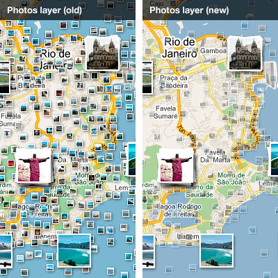
There are a couple interesting things happening with online maps today. Google has updated its Photos layer and MapQuest has introduced Atlas.
Google’s update has three main improvements. "Firstly, we have made improvements to the density of the photos on the map, making it easier to see clusters of photos in popular locations," explains Jonah Jones, User Experience Designer on the Google Maps Team. "On the screenshot above, you can now well see that there are a lot more photos taken on the coast than there are inland."
"Secondly, we’ve made the small thumbnails partially transparent, making it easier to see the underlying map, and helping you to stay oriented," adds Jones. "Finally, we are showing more information when you hover over a photo. Now, you can see a large thumbnail and the title of each image, so you can get a fast preview of what any photo looks like."

MapQuest’s Atlas is an encyclopedia-like service. Atlas lets you click around on places from the map view, and will bring up dedicated pages for those places with additional info, including categories like Introduction, Geography, People, Government, Economy, Communication, etc.
It’s set up a bit differently than Google’s strategy of including a Wikipedia entry. While Atlas probably has better-organized information about geographical places, Google’s Wikipedia layer probably provides a lot more info about more specific places. Both will no doubt improve over time.


 WebProNews is an iEntry Publication